When I used the Maps menu in Family Tree Analyzer (FTA), I discovered something I needed to fix. Even though I can find many addresses from my tree on Google Maps or Bing Maps, they weren't recognized by FTA.
I opened my tree in Family Tree Maker, which uses Bing Maps for locations. I noticed it could be very imprecise, or just plain wrong, about some locations. I wanted to improve these results so I could do more with FTA's Maps menu. The solution was to add Latitude and Longitude coordinates. And it's easy to do.
 |
| If small-town locations in your family tree are hard to find IRL, these two numbers will bring you right to the front door. |
Here's how to add these precise coordinates to your computer-based family tree software:
- Find the exact location on a map website. I like Google Maps for this because of its streetside view. I want to see that I've got the right place, and even find the front door.
- Right-click at a precise location to see the map coordinates. (You must exit Street View first.)
- Enter the Latitude and Longitude numbers in your family tree.
I use Family Tree Maker, but RootsMagic also has fields on the Places menu to enter map coordinates. I'm sure other desktop genealogy programs do, too.
Family Tree Maker tells me I have 5,323 places in my family tree, so I'm not going to do this for every location. My goal is to use Family Tree Analyzer to see how many people got baptized or married in a particular church. So for starters, I'm pinpointing the locations of different churches in my family tree.
Watch Your Results Get Better
Here's an example of the benefits of this project. Before I added map coordinates to one church in Benevento, Italy, Family Tree Maker had their pin a few miles south of the city. I have no idea why. Now, with the coordinates in place, FTM knows precisely where to find this church. And so do I, should the day come when I want to visit it. As I look at the map, I see that I've been within a few yards of this church, but I didn't know it!
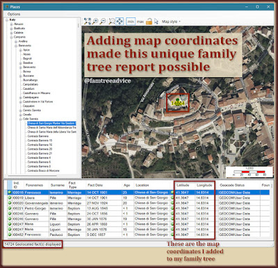 |
| How many people in your family tree were at this address? Family Tree Analyzer can tell you, but you may need to feed it a couple of numbers. |
With a few churches pinpointed in my family tree, I'll export a new GEDCOM file to open with Family Tree Analyzer. I'd like to see how many births and baptisms I've associated with the church in Colle Sannita, Italy.
In Family Tree Analyzer, once you open your GEDCOM file, click the Maps menu and choose Show Places. Say No to the pop-up message about Geocode locations. Now choose a particular location.
I clicked through the list of places and drilled down to the church. Italy, Campania, Benevento, Colle Sannita, Chiesa di San Giorgio Martire. There's my answer. I've attached this location to 14,724 baptism or marriage facts. And because of the map coordinates, the location is very precise.
Recently I've been reviewing some of my early research work on the town of Baselice. I was brand new to Italian vital records when I recorded many of these facts. I remember I didn't want to assume each baby got baptized in the town church. Now I know better. And I can see that the church is in fact mentioned on the birth or baptism records. I'd like to correct those baptism facts and increase the number of uses of the church in Baselice.
Make Your Map Pins Portable
I'm excited to use these map coordinates the next time I visit my ancestral hometowns. Family Tree Analyzer can export all the places from your family tree to "Google My Maps." I gave this a try, and it saves a file to your computer in a text-based format. When I go to My Maps in Google, I see that I can import the file.
Sure enough, all 5,323 locations from my family tree are now on this one map! I've never been to my 2nd great grandmother's hometown of Santa Paolina, Avellino. But when I get there, I can use Google Maps to pull up the precise location of the town church and step inside!
 |
| Family Tree Analyzer can put every single location from your family tree on one map—complete with names and dates. |
To get to Google My Maps, start at google.com/maps and click Saved in the left menu. Then click Maps and Open My Maps. I've created maps before, but uploading thousands of locations at once is fantastic! I can click any location to see who's associated with that place. There's also an option to open this map collection in Google Earth. This seems like the best way to see your places in living color, rather than basic map view.
Now I needed to turn my iPhone into my family tree navigator. I installed Google Earth and put Family Tree Analyzer's exported places file on my phone. In Google Earth, I chose Projects, then Open, then Import KML file. (That's the format of the FTA locations file.)
Now no matter where I am, I can open Google Earth and zoom out see which family tree locations are nearby. Then I can tap any map pin to see what happened there. Don't you want to have this on your phone?


